
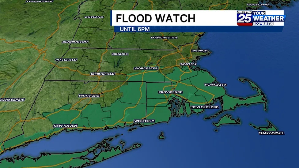
Severe weather alerts have been activated throughout large portions of southern New England, with state and regional forecasters warning Massachusetts communities about rapidly developing flash flood conditions. A powerful band of persistent rainfall is moving across the region, prompting weather specialists to advise residents to stay alert to swift changes in local environmental and road conditions.
The National Weather Service issued a targeted flash flood warning for Southwestern Bristol County in Massachusetts, maintaining heightened vigilance through 1:45 p.m. Forecasters indicated that incoming deluges could overwhelm drainage infrastructure in the area within a short timeframe, presenting an immediate hazard to low-lying terrain and critical local thoroughfares.
In addition to the localized warning, a broader flood watch has been placed into effect covering an extensive swath of Massachusetts counties. Emergency managers confirmed that the watch encompasses Bristol, Plymouth, Barnstable, Dukes, Nantucket, Worcester, Norfolk, and Suffolk counties, remaining active through 6 p.m. on Sunday as heavy precipitation sweeps across the commonwealth.
The Boston 25 Weather Team escalated the regional alert level, declaring a Severe Weather Alert to ensure the public remains aware of escalating atmospheric moisture and pooling water hazards. Meteorologists emphasized that communities must remain proactive as rain bands traverse the state from the morning into the late afternoon hours.
Providing deeper insight into the storm's path, Boston 25 meteorologist A.J. Mastrangelo explained that a concentrated cluster of heavy precipitation would progress across Southeast Massachusetts beginning late in the morning. He highlighted that flood watches are established primarily along and south of the Massachusetts Turnpike, marking this corridor as a focal point for the wettest and most troublesome weather conditions.
Meteorological analyses indicate that the system consists of general showers interspersed with embedded thunderstorms. These storm cells possess the capacity to develop narrow, concentrated corridors of intense precipitation, which significantly amplifies the risk of sudden standing water in communities that find themselves directly beneath the storm tracks.
Widespread rainfall across the affected Massachusetts counties is projected to accumulate between 0.50 and 2 inches under the primary storm system. While these baseline amounts are substantial, the overarching concern stems from the localized bursts of extreme precipitation embedded within the broader weather pattern.
Forecasters caution that narrower, highly concentrated storm bands could dump between 2 and 4 inches of rain within a compact three-hour window. Such rapid accumulation rates typically outpace the absorption capacity of regional soils and overburden municipal storm drain networks, drastically accelerating the transition from damp streets to hazardous flash flooding.
The National Weather Service noted that although some uncertainty persists regarding the exact placement of these intense rainfall bands, the potential for localized flash flooding remains a serious concern. Meteorologists highlighted that the danger will be particularly acute if these torrential downpours settle directly over densely populated urban centers or low-lying commercial zones.
Government weather experts have explicitly identified several high-risk environments prone to rapid inundation during this storm. These vulnerable areas include small creeks, local streams, urban corridors, multi-lane highways, city street intersections, transit underpasses, and regions characterized by poor drainage systems or low elevation.
In light of the hazardous travel conditions, meteorologists and public safety officials have reiterated critical life-saving advisories for drivers. The National Weather Service strongly reminded motorists never to drive through water-covered roadways, reiterating the essential caution that most flood-related fatalities take place when people attempt to navigate vehicles through flooded sections of roads.
To support public safety and resource management, the Massachusetts Emergency Management Agency (MEMA) has made state tracking tools available to residents. State emergency coordinators are advising citizens to monitor ongoing developments closely and take precautionary measures to safeguard family members and personal property.
Among the resources provided, MEMA is directing the public to its real-time power outage tracking platform. This utility dashboard allows residents to monitor localized electrical disruptions, track regional outage statistics across the state, and review official restoration time estimates provided by regional utility companies.
Residents are also encouraged to make use of MEMA's live weather radar capabilities and complementary forecasting applications. These digital tools enable individuals to observe approaching storm cells in real time and evaluate the specific threat levels facing their immediate neighborhoods before setting out on the roads.
State and federal support channels remain accessible throughout the weather event to assist individuals requiring community resources or updated safety guidance. Organizations such as Mass211 and the Federal Emergency Management Agency, alongside National Weather Service forecast offices in Boston and Albany, New York, continue to provide regional meteorological information and community assistance.
Residents situated along and south of the Mass Pike are urged to remain mindful of weather updates until the flood watch officially concludes at 6 p.m. Sunday. Continued vigilance, avoidance of submerged road segments, and regular checks on local forecasts remain the most effective steps for navigating the severe weather safely.






(0)